 |
| McColl Property: Yellow line represents where I understand the Pleistocene Catawba River Path was. The Red line represents I-77 |
 |
| Pleistocene Catawba Riverbed |
 |
| Site on Catawba River for the new York County Nature Museum |
 |
| Coyote Scat |
As we looked around the ancient riverbed, we noticed blackberry bushes and coyote scat. Animals had created a trail. Steve Fields, MYCO Curator of Natural History, told us coyotes and domestic dogs have an anal gland that secretes a fluid used to mark territory. Perhaps the coyote had marked territory along the trail. We also noticed bleached white animal hair in the coyote scat.
Anyway, back to the past...the basement rock/bedrock is uplifted granite, felsic (Fe = iron) rock in an uplifted pluton (chamber of cooled, molten rock). The characteristic red clay is weathered granite. The red color, iron oxide (felsic, Fe = iron).
 |
| Red eyed vireo |
 |
| Scarlett Tanager |
We then heard a Scarlett Tanager http://www.allaboutbirds.org/guide/Scarlet_Tanager/id
Also in the power line right of way, we saw an Eastern fence lizard http://www.wildherps.com/species/S.undulatus.html
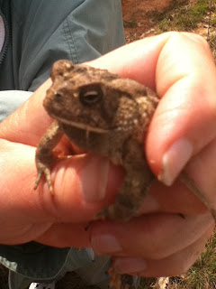
We also saw a Fowler's toad under a discarded board.
 |
| Fowler's Toad |
 |
| Bracken Fern |
We made our way down the bluff, to the man-made deck/overlook, about 20 feet above the river. There, we enjoyed lunch and the excitement of our fortunate observations. We also got to practice keying out ferns. The Bracken fern is one we've seen at several of the sites.
While at the overlook, we saw Squaw root and American Hornbeam http://www.duke.edu/~cwcook/trees/caca.html
c
 |
| Squaw Root by J. McGill |
 |
| American Hornbeam |
Something that has always fascinated me, because it is clever, is a fish weir constructed by Native Americans, in the river using rocks. They placed the rocks at an angle, diverting the fish coming down the river into a narrow opening, making it easy to spear them.
The picture on the right, came from another blog: http://wakinguponturtleisland.blogspot.com/2008/05/new-nonnewaug-road.html
There were numerous weirs along the Catawba. Here is one near Lake James.
 |
| Tip of Yellow Arrow Marks Tip of Weir |
The next picture was taken at the new York County Museum/McColl site on the day of the trip.
 |
| Catawba River, McColl Site, Fort Mill, SC by J. McGill |
On the way back up the bluff, we saw a Fiery Searcher beetle, along with Box elder, Slippery elm, May Apples, Adamascar lily, and Crossvine.
 |
| May Apple |
 |
| Adamasco Lily Zephranthes atamasco |

